Handover:
Wednesday
20 - Thursday 21 February 2002
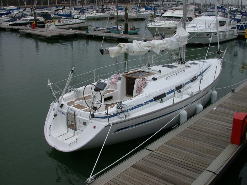
Sparkes' Marina, Chichester Harbour, to Port Hamble
Marina, Hamble
(Click
on any of the photographs below to see a larger image)
Delivery Trip
from Chichester Harbour to the Hamble
After
handover, we, the owners, had to take Bagadeus to Port Hamble Marina, Hamble, for final fitting out and
charter coding. This relatively short (20 mile) trip was planned
originally for handover day, Wednesday 20th February 2002.
However
the weather was not good on 20th February. High winds were forecast
and experienced all day - we saw gusts of up to 40 knots on bagadeus'
anemometer for most of the day and evening. The reported sea state
was 'rough to very rough'. Conditions over the Chichester Harbour
bar would be dangerous; it was, all in all, weather in which yachts like Bagadeus
stayed in port and waited for better weather.
A small high
pressure ridge was forecast to form early on Thursday and was expected to
last into the afternoon, during which the wind would drop to F3/4 and veer
to north/northwest, before another depression arrived with the wind
backing and increasing again to F8/9. North/northwest would mean
that there was no fetch to the waves, and the sea should quieten
considerably. Consistent with the this, the sea state during the
weather window was forecast to be "slight to moderate" -
perfectly satisfactory for the short trip round to the Hamble.
 The weather
forecasts were watched keenly using the Navtex receiver on Bagadeus.
At one stage on Wednesday evening the forecast weather window dropped
out of the forecasts, causing some concern. However by midnight the
temporary high pressure ridge was back in the forecasts.
The inshore waters forecast at 00:48 predicted that the ridge would form during the
morning and last until the afternoon.
The weather
forecasts were watched keenly using the Navtex receiver on Bagadeus.
At one stage on Wednesday evening the forecast weather window dropped
out of the forecasts, causing some concern. However by midnight the
temporary high pressure ridge was back in the forecasts.
The inshore waters forecast at 00:48 predicted that the ridge would form during the
morning and last until the afternoon.
And so it
transpired. From around 04:00 hrs. on Thursday morning the wind
dropped and turned northerly; a few hours of this wind would almost
certainly mean a quiet sea with no problems over the bar.
After some
final checks Bagadeus departed Sparkes' Marina at 10:30 at low
water, albeit neaps. Over the hump in the approach channel to the
marina the echo sounder was indicating 0.1/0.2 m, and at one point dropped
to zero (the echo sounder had been set with a 2m offset and Bagadeus
draws 1.85m, so at that point she had 15 cm or less below her keel).
 There was about
0.5m at the lowest over the bar. The new chartplotter was a great
help in crossing the bar; using the plotter display in front of the
helmsman it was relatively easy to steer so as to keep the little boat
symbol which marked our position over the deepest part of the
channel. We had already entered a route into the chartplotter (West
Pole - Winner - Horse Sand Fort - Browndown - North Channel eastern
entrance - Reach - Hamble Point). Having passed West Pole
beacon we turned onto course for the Winner buoy. It was important
not to drift north of the track because of the Winner Bank shallows, so we
engaged the autopilot's 'track' function to ensure we maintained the
planned track over the ground direct to the buoy. This worked well -
the "rolling road" GPS display confirmed we were keeping exactly
on track.
There was about
0.5m at the lowest over the bar. The new chartplotter was a great
help in crossing the bar; using the plotter display in front of the
helmsman it was relatively easy to steer so as to keep the little boat
symbol which marked our position over the deepest part of the
channel. We had already entered a route into the chartplotter (West
Pole - Winner - Horse Sand Fort - Browndown - North Channel eastern
entrance - Reach - Hamble Point). Having passed West Pole
beacon we turned onto course for the Winner buoy. It was important
not to drift north of the track because of the Winner Bank shallows, so we
engaged the autopilot's 'track' function to ensure we maintained the
planned track over the ground direct to the buoy. This worked well -
the "rolling road" GPS display confirmed we were keeping exactly
on track.
 The sea was
calm as anticipated, but the wind, although only F3, was heading us so we
continued on engine. the Winner buoy duly appeared ahead and we
turned onto the track for Horse Sand Fort. Around this, and on to
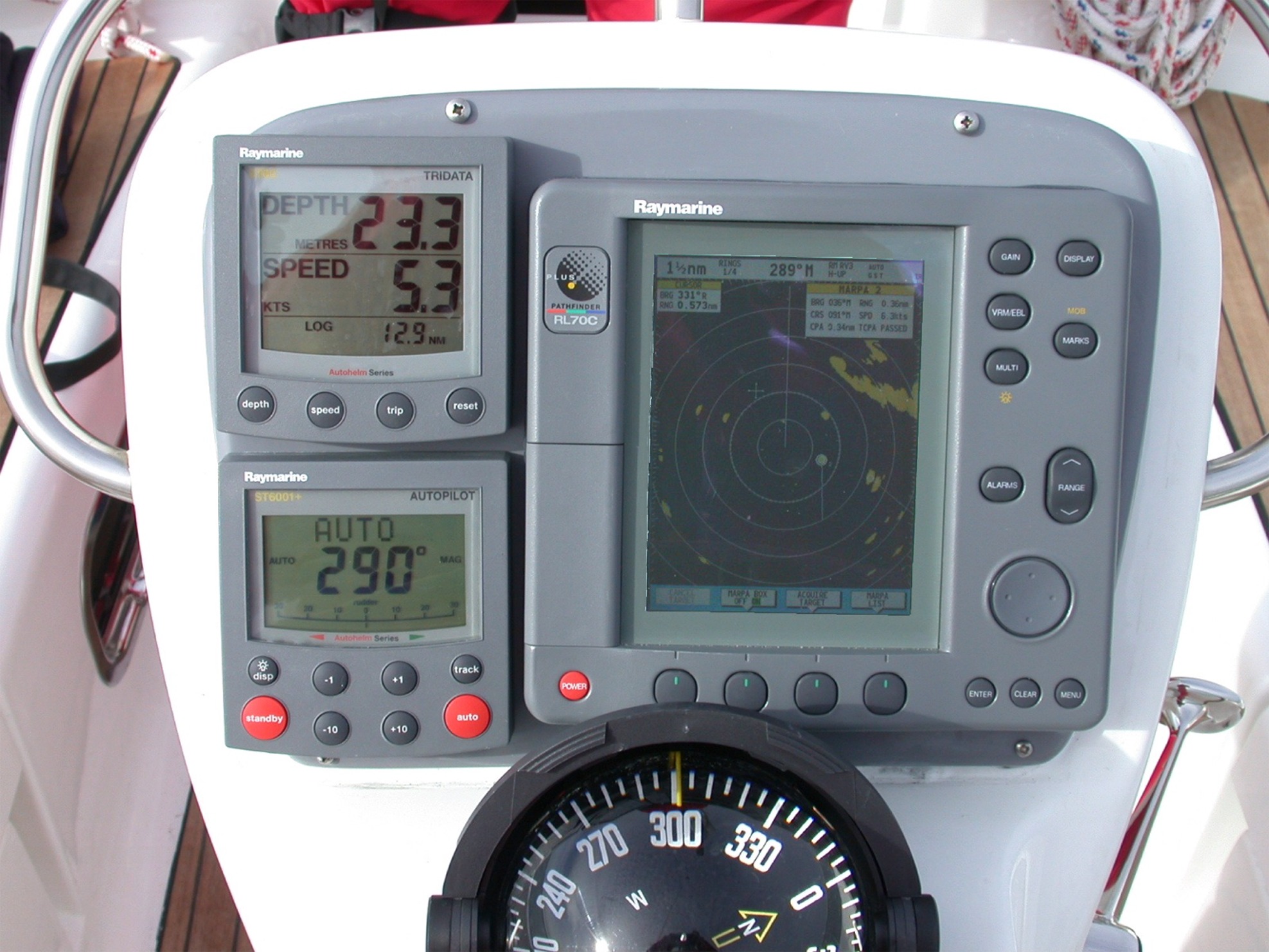
Browndown. By this stage we had switched on the radar. We
encountered, as frequently in the Solent, a ferry which presented a
possible collision risk so we invoked the radar's MARPA
(Mini Automatic Radar Plotting Aid) capability, now standard in the Plus
range of Raymarine radars. The results were impressive - see the box
below for details.
The sea was
calm as anticipated, but the wind, although only F3, was heading us so we
continued on engine. the Winner buoy duly appeared ahead and we
turned onto the track for Horse Sand Fort. Around this, and on to
Browndown. By this stage we had switched on the radar. We
encountered, as frequently in the Solent, a ferry which presented a
possible collision risk so we invoked the radar's MARPA
(Mini Automatic Radar Plotting Aid) capability, now standard in the Plus
range of Raymarine radars. The results were impressive - see the box
below for details.
As we entered
the North Channel into Southampton Water, the wind began to back and
increase. The weather window was clearly coming to an end, but no
matter - we were now in relatively sheltered waters. We briefly
tried the sails and were impressed. The main went up easily, and the
single line reefing system is extremely easy to use; it is operated
entirely from the cockpit - no need to go on deck to reef.
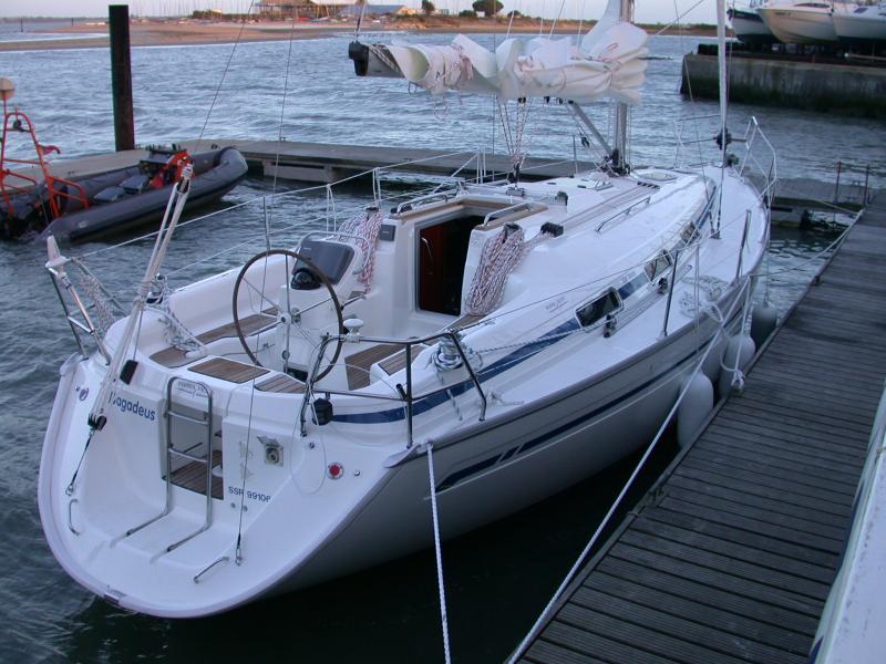
Finally to
Hamble Point buoy for the turn into the Hamble river, and to Port Hamble
Marina. Bagadeus was left in the care of her Charter Agents for
charter coding work. She is currently available for charter from
Hamble Point Yacht Charters at Hamble Point Marina.
|
 Click to see a larger picture,
which may take 1-2 minutes to download, but is necessarily large in
order to see essential detail.
Click to see a larger picture,
which may take 1-2 minutes to download, but is necessarily large in
order to see essential detail.
If you have IE6 or above the display will compress to fit in
the browser window after downloading. In this case, hover the mouse
over the image, wait for the "expand image" icon to appear
and click on it to see the full detail. |
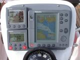
The radar display on the left was photographed during
bagadeus' delivery trip to the Hamble and shows the Solent,
with bagadeus' position and heading indicated by the black
boat-shaped icon; she is heading for the North Channel into
Southampton Water with Gilkicker Point on her starboard bow.
Two targets which have been tracked using the Radar's MARPA
capability are on the screen. The first (a ferry) had been
considered a collision risk and is now in the Swashway heading into
Portsmouth (note the predicted vector extending ahead of the target)
with another vessel ahead of her clearly visible on the radar.
The second (a motor yacht) has just passed Bagadeus at a
minimum separation of about a third of a mile, starboard to
starboard. As for the first target, the predicted vector is
shown. The MARPA box shows the second target's bearing,
distance, course, speed, CPA (Closest Point of Approach) and TCPA
(Time to ....... - now passed).
|
|
Click to see larger picture -
note comments above about download time and IE6 implications
|
The chart display shows the same
situation about 30 seconds later (note the log which indicates a
further 0.1nm). The second target has altered course to
starboard and slowed a little and presumably intends to pass south
of Horse Sand Fort.
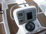
The binnacle compass was due to be swung and corrected after
delivery to the charter agents - note the 10 degrees deviation
compared with the autopilot's fluxgate compass.
|
Click to see
larger picture. |
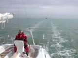
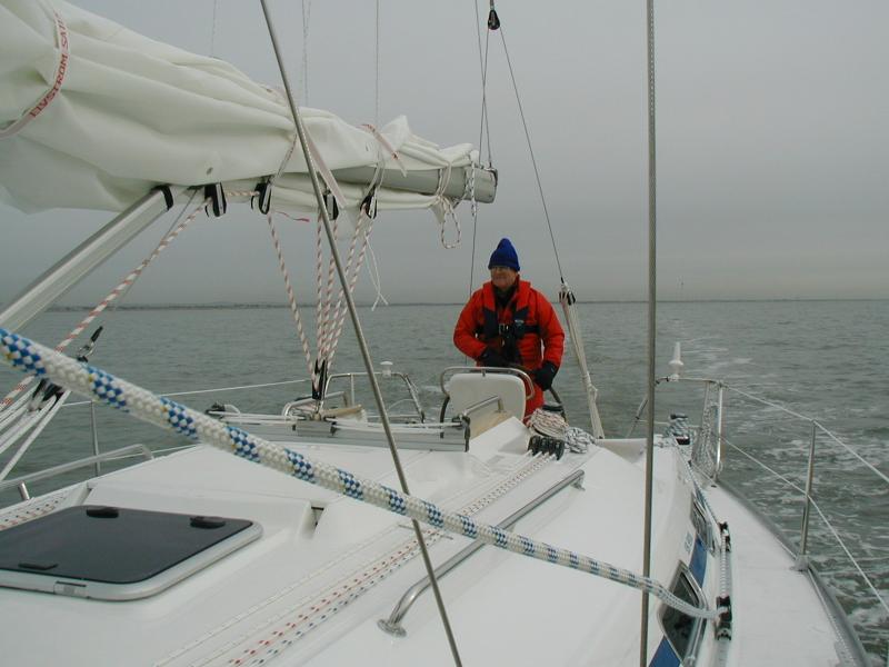
Bagadeus passed south of the Horse Sand Fort about 20 minutes previously; the fort can
be seen astern of Bagadeus in the photograph on the left,
taken shortly before the photographs of the radar and chart
displays.
Note the wake which illustrates the steering
accuracy of the autopilot.
|


